


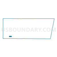
ELA 97 Voting District, Lake County, Illinois
About
Outline

Summary
| Unique Area Identifier | 572273 |
| Name | ELA 97 Voting District |
| County | Lake County |
| State | Illinois |
| Area (square miles) | 2.64 |
| Land Area (square miles) | 2.51 |
| Water Area (square miles) | 0.13 |
| % of Land Area | 95.00 |
| % of Water Area | 5.00 |
| Latitude of the Internal Point | 42.19167420 |
| Longtitude of the Internal Point | -88.03271350 |
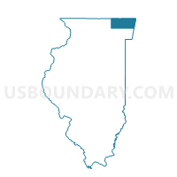
Maps

Graphs
Select a template below for downloading or customizing gragh for ELA 97 Voting District, Lake County, Illinois


Neighbors
Neighoring Voting District (by Name) Neighboring Voting District on the Map
- ELA 100 Voting District, Lake County, IL
- ELA 81 Voting District, Lake County, IL
- ELA 82 Voting District, Lake County, IL
- ELA 84 Voting District, Lake County, IL
- ELA 94 Voting District, Lake County, IL
- ELA 95 Voting District, Lake County, IL
- ELA 96 Voting District, Lake County, IL
- ELA 98 Voting District, Lake County, IL
- VERNON 276 Voting District, Lake County, IL
- VERNON 277 Voting District, Lake County, IL
- VERNON 278 Voting District, Lake County, IL
Top 10 Neighboring County Subdivision (by Population) Neighboring County Subdivision on the Map
Top 10 Neighboring Place (by Population) Neighboring Place on the Map
- Lake Zurich village, IL (19,631)
- Long Grove village, IL (8,043)
- Kildeer village, IL (3,968)
- Forest Lake CDP, IL (1,659)
Top 10 Neighboring Elementary School District (by Population) Neighboring Elementary School District on the Map
Top 10 Neighboring Secondary School District (by Population) Neighboring Secondary School District on the Map
Top 10 Neighboring Unified School District (by Population) Neighboring Unified School District on the Map
Top 10 Neighboring State Legislative District Lower Chamber (by Population) Neighboring State Legislative District Lower Chamber on the Map
Top 10 Neighboring State Legislative District Upper Chamber (by Population) Neighboring State Legislative District Upper Chamber on the Map
Top 10 Neighboring 111th Congressional District (by Population) Neighboring 111th Congressional District on the Map
Top 10 Neighboring Census Tract (by Population) Neighboring Census Tract on the Map
- Census Tract 8644.02, Lake County, IL (7,277)
- Census Tract 8645.11, Lake County, IL (6,564)
- Census Tract 8644.08, Lake County, IL (5,743)
- Census Tract 8644.10, Lake County, IL (5,219)
- Census Tract 8644.03, Lake County, IL (5,206)
- Census Tract 8645.15, Lake County, IL (2,874)